
Towards elite –
How to join it all up
In this section we think about total immersion in the process of spatial thinking and improving visualisation. There is no end to how far you can take this and it requires you to reflect in much more detail on how you prepare for a race and how you respond to the challenges within it. This requires a more sophisticated understanding of what is going on when you are navigating and learning how to optimize your ability to use all that you know and have practiced.
Most experienced orienteers are somewhat aware of what will be discussed in this section, but not so many apply it in any depth because it cannot simply be read and then done. You will need to go through many cycles of attempting to implement these ideas, then analysing what could be improved and trying again and you need to relate this evaluation to your personal strengths and weaknesses. For example, if you are good at Terrain Visualisation then a more risky route that will require some Relocation on contour features becomes more viable than a safer longer one.
Once your orienteering is at this level, if you are performing well, further in-depth coaching may help you to personalize these ideas. The highest level of orienteering is a process where you try, reflect on what went well or went wrong then try again in a continous cycle. Even though orienteering requires exceptional fitness it remains more about the mind than just fitness.
It is also worth remembering that orienteering navigation at speed is such a complex set of skills that you will never have it all sorted and needing no improvement. There is always room for improvement and it is common for even the most experienced elite competitors to find that as they work on one area of weakness and improve that, they then have to turn their attention back to another area that needs working on again. Its a never-ending process, but hopefully an enjoyable one. You can think of it as a continuous cycle of fine tuning. The winner is the one who is best managing to combine their entire skills set and experience as an orienteer with a very high level of fitness.
It doesn’t have to all be in words
A music analogy is helpful. A beginner at the piano struggles to translate every note on the score into an action on the page. A better pianist sees phrases and can also look ahead as their hands reliably play the notes. A concert pianist is so totally immersed in playing that they are hearing the orchestra as much as themselves, they are lost in the emotion of the music and can bring a piece to life. They simply couldn’t have irrelevant words in their head when doing something so complex. Did you realize that many elite level orienteers experience a similar phenomenon?
Are you overloading your brain with too much chatter? We said earlier, “Don’t talk to other people”. It can also be worth talking to yourself less in your inner monologue. Orienteering control descriptions are pictorial. Can you picture in your mind the feature you are seeking without having to put it into words? Or can you abbreviate it to the minimum? You can then picture the feature placed in the overall shape of terrain, associated with Notable Features en route, an Attack Point and maybe a Catching Feature. Your mind is an awesome spatial information processor, try out what more it can do in terms of visualisation!
Source: http://www.tovealexandersson.se
Most people process images faster and more reliably than they process written words. Orienteering is a visual processing task and that part of your brain needs to be switched on and getting the highest level of attention from your mind, but it doesn’t need to always be interfaced by the verbal part of your brain. I suspect that orienteering selects for what might be called ‘Hyper visualizers’, who are especially good at visualization. One piece of evidence I have observed, is that severely dyslexic people can still be exceptionally good navigators because it is a different type of thinking, not requiring reading words.
Visual processing is easier and faster than verbal reasoning which leads to our next point about Mental Maps and Terrain Visualisation.
Improve your mental maps and visualisation
When you know a journey well you don’t need to narrate the turns and directions needed to make the journey. If you think of undertaking it, you see it in your mind; you visualize the journey, then you carry it out. To get to a high level in orienteering you need to be able to form confident, reliable visualizations in your mind’s eye and then use them to navigate successfully.
Stop seeing the map as collections of symbols with corresponding words attached to them as though you are reading a book, the words are an extra processing task you don’t need. The map is a pictorial summary of a 3-dimensional landscape that you can picture in your mind as you move through it. Perhaps the problem is that we call it map reading which immediately associates it with words, rather than Terrain Visualisation, which is what is really going on.
The visualisations that can be created with Quick Route and 3D Rerun are helpful to show what we are talking about.
See http://www.matstroeng.se/quickroute/en/index.php

Map reading is the process of uploading spatial information and forming a mental map and a visualisation of the terrain, that you can place yourself within and to which you can add information and focus in more closely where needed during a leg. The better your mental map and visualisation, the more confidently you can use it when moving through terrain. Some orienteers say they are flowing through their visualisation of the terrain with hardly any words going through their mind. They don’t need them and are too busy with other navigation tasks.
Your mental map is an edited version of the real map with selected features to enable you to successfully execute your route choice. This concept was introduced in the Intermediate section and summarised by Göran Andersson describing advice from Thierry Gueorgiou (reproduced with permission from Göran Andersson’s book ‘Cool, Awesome and Educational Orienteering at school ages 6-15’)
Your visualisation is how you expect to see the features in your Mental Map as you encounter them in the terrain.
It is worth noting that your Mental Map and Visualisation are strictly speaking not the same thing. Your mental map is built from a simplification of the actual map. You then visualise that in 3D and you monitor the terrain you see with your eyes against the visualisation you have built in your mind from your mental map. It is of course a two-way process where what you see links back through your visualisation to the map. That may seem like a seamless process when you do it, but there are steps to it and weaknesses in any part of that chain can lead to navigation errors. This could be a much longer discussion, but that is enough detail for now.
Visualisation and how to train to improve it is discussed in detail in Michel Gueorgiou’s book The Winning Eye (see Books and Resources section).
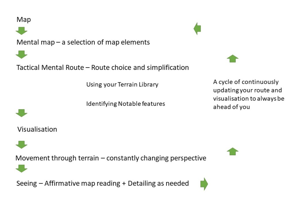
When you are orienteering, there is the terrain, then there is the map summarising that terrain created by a skillful mapper and there is the mental map and visualisation in your head. You can’t change the terrain. Orienteering maps nowadays are awesome. The weak link here is the mental map and visualisation in your head! It is what is needing the most improvement.
| The aim is to go as efficiently as possible from paper map, to mental map, to visualisation, to accurate movement through the terrain |
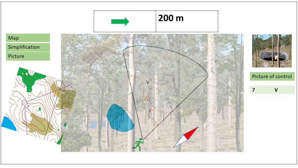
In this video, ‘Albin Ridefelt would probably not approve of my route choice’, Janne Troeng demonstrates the process of Picturing the shape of the terrain from the map, selecting notable features on route (check points) and forming a strong Picture/ visualisation of what you will encounter on the leg, then running through it! If you can’t do this, then navigating at speed in complex forest with low visibility will be almost impossible.
The example leg of a course discussed in this video can be related back to the model – Plan, Picture, Direction


Forming your mental map and visualisation means drawing together many skills – accurate map reading, contour interpretation, route choice, route simplification, identifying notable features in a corridor and more. There is no quick way to get good at this and you can always improve it and every leg involves a new combination of these elements. Fine navigation, immersed in detailed map reading, is one of the main training techniques you can use to help you actively work on your Mental Maps. For training, following a line on the map accurately on the ground is good practice. Night orienteering is also good practice because it forces you to Picture well from the map because you can’t see so much around you.
Michel Guergiou calls the mental map that the orienteer builds from their map reading and route choice the Tactical Mental Route. Specific elements of the map and terrain are linked together in the orienteer’s simplification of the map, to produce a mental map that can be visualised as a reliable and efficient route to the next control. (see The Winning Eye).
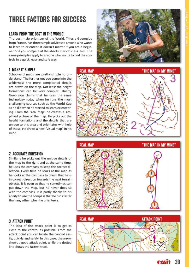
The process of selecting those features that form the Mental Map can be thought of in relation to how visible they are to the runner moving ahead. Notable features can be identified to allow simplification of complex details, so that the orienteer can safely speed up, not having to follow every detail on the map and remain accurately on their chosen line. Thierry Guergiou describes how he simplifies and visualises in this article on World of O:
Thierry Gueorgious story part 1
Thierry Gueorgious story part 2
We will now look at some analogies to help model what is going on with visualisation.
A Sat Nav analogy –
Source: Wikipedia: By Erik Streb – Own work, CC BY-SA 3.0, https://commons.wikimedia.org/w/index.php?curid=14681419
When navigating you need to zoom in and out of the detail of the map in your head as needed by different navigation challenges and your place within a leg. In an earlier section we used the analogy of a Sat Nav zooming in and out of detail as a simple analogy, and we can look at it in more detail again.
As you start a journey Sat Nav shows you an overview of the route with several options and you make a route choice. Then it zooms in, showing lots of detail, to help you set off in the right direction but as you move along a hand rail (road) it zooms out again to a simplified view. It zooms in again at critical decision points along the route and confirms whether you have taken the right direction, and finally it zooms in again as you near the destination. At any point it can zoom out to the whole journey or a section of it to give an overview and simplify what you are seeing or can zoom in for more detail of a decision point such as a junction.
A Sat Nav will also preview the decision points on a route, such as junctions, so that as you approach the junction you know what to expect and which way to turn. You need to identify those decision points in your route and zoom in on the map detail before you get there so that you are ready to make the right choice of direction when you reach that point.
This analogy of zooming in and out is quite helpful for thinking through the different types of interaction you will have with the map in planning a leg and making your route choice, then executing the leg with further micro-route choices on route. When you look at the map frequently whilst running, you will be looking at it with different levels of zoom depending on what information you are updating in your visualisation at that point. You will need to be building in your mind the visualisation of the overall leg, then adding details within it, but also looking ahead to the next leg so that you know the next route choice and thus exit route from the control.
Heads Up Display analogy –

You must always have a reliable visualisation in your head, that you are running into.
Imagine if someone were to run the course before you on the optimum route and create a perfect head up display for you to follow. You could then run through the terrain wearing a head set showing that route with a map, a simplified route to follow with notable features highlighted, decision points shown before you get there and direction arrows showing which way to turn and how far to you have left to go to the next notable feature and to the control. It would be almost impossible to get lost and the only limiting factor would be your ability to run!
The graphic below uses visualisation elements from The Forest, to try to summarise some of what is in the runner’s mind’s eye: The map and course have been analysed to a route choice, a mental map with that route has been visualised to a picture of what is ahead, the control site has been pictured as well The runner is aware of their place in the terrain because of their accurate mental map and visualisation and is heading in the right direction. They are constantly updating this visualisation and confirming their place within it as they move.
The challenge is to be creating and pre-loading a good visualisation like a computer uploading and buffering a video in advance of where you are in viewing it, so that you personal heads up display is always up to date and ahead of you. This visualisation diagram previewed in the Advanced skills section is another way of trying to illustrate this process. The map is shown as being looked at with different levels of magnification or “zoom” at different points in the leg.

The challenge of orienteering navigation is to build such a good visualisation from the map that it is in effect a head up display you can run through limited only by your fitness. Whatever you see with your eyes, the visualisation in your mind’s eye has already predicted.
Types of map contact – Martin Lerjen
Martin Lerjen discusses what he calls Visionary Head Start. He explains how it is essential to always visualise ahead of yourself, to allow you to have good flow and high speed. “If you have visionary head start, then you can navigate and run at full speed“.
Martin introduces the article this way:
“In this discussion paper, I introduce five types of orienteering map reading: retrospective, reading-the-next-step, visionary, affirmative, and detailing. Four properties define the types and, in general, you can group the types as “bad” and “good.” I also introduce a way to visualise your map reading techniques. The paper is based on the concept of “visionary head start” and is inspired by several elite orienteers and my own work as an orienteering coach.”
The article is here:
Follow up of Gueorgious part 2 Analyse Your Map Reading
He also does something extremely helpful by identifying different types of contact with the map that are going on in orienteering navigation;
Retrospective map reading- this tells you where you have been. This is a slow way to navigate. Beginners tend to think about navigation in this way. It can be necessary in relocation, but essentially your flow has stopped and you are looking backwards.
Reading-the-next-step map reading- this allows you to identify the next feature or decision coming up but no further. This is a natural progression from thinking about where you have been but it only enables stop/start progress between points on a route.
Visionary map reading – you know where you are going towards a new “beacon” or notable feature.
Affirmative map reading – you confirm where you are as you see features in the terrain.
Detailing – you add detail to your existing visualisation for part of a leg, this can include adding more detail as you come into the control circle.
These different types of map contact come together to allow you to build and maintain a robust and reliable visualisation. They can be related back to the Sat Nav analogy or the Heads Up Display analogy (which is another way of imagining the same thing). These ideas also informed the Map Reading and Visualisation diagrams in the Intermediate section that characterise how people tend to orienteer at different skill and experience levels:
Relating these insights and models of orienteering back to Plan, Picture, Direction
It is important that we do not get lost in the terms and discussion so I think it is helpful to relate this back to Plan, Picture, Direction. This model was developed by Duncan Bayliss, (drawing on the discussion and terms used by Kris Jones in an article on performance analysis- see Further Articles on Skills.)
The model is a memory aid. It does not need to include every part of what has been discussed here because if you understand them, as a simple memory aid it can help you pull those ideas together when actually navigating. A complex model may help with post-race analysis, but you need something simple in your mind when when navigating.
It may seem like repetition to return to this model, but the more experience you have and the more you understand of orienteering navigation, you can still relate it back to this model. Ideas from Thierry Guergiou, Michel Guergiou, Martin Lerjen and Kris Jones that we have considered across Better Orienteering are referred to by key words to link them to the model as a way of integrating all that has been discussed.
(Tactical Mental Route and Terrain Library are terms taken from Michel Guergiou, 2019. Affirmative map reading, Detailing and Beacons are terms from Martin Lerjen)
Plan – this involves route choice and building what Michel Guergiou calls a Tactical Mental Route e.g. a reliable and efficient way to get to the next control from which you can build a strong visualisation. That Tactical Mental Route involves a building a Mental Map with many elements but it is a simplification of the full map and the real terrain that you are moving through. The more experience you have and the better your Terrain Library, the better you become at selecting the right features on the map to build into your route, mental map and visualisation.
Picture – this involves constantly updating an effective visualisation of the route ahead of you and is again very dependent on your Terrain Library giving you the elements you need to make a good visualisation. This is constantly being updated. You make an overview and add detail as you need to. You are continually doing this and no longer think just one leg, one control at a time, you know your exit from the control and the outline of the route to the next control after this one.
Zoom – Building your Plan and updating your Picture require different types of map contact at different times – Visualising, Detailing, Affirmative.
Direction – as you move through the terrain you are always moving into your visualisation which is ahead of you. Different navigation approaches are used at different points in a leg and according to how complex the navigation problem is, always maximising the value you get from your compass. With a good visualisation ahead of you and close attention to the compass you can still move quickly though terrain with complex details and low visibility because you are not relying on first seeing features with your eyes and then matching them to the map as orienteers do at lower skill levels. You are seeing features in your minds eye first and then moving accurately to or past them. Affirmative map contact keeps you placed accurately within your visualisation.
Relocation – this should be about readjusting your visualisation with some detail knowing where you are within an overall placement in the terrain, not responding to being “lost”. By zooming in and Detailing, you place yourself more precisely and continue your flow. Ideally you don’t let your visualisation break down to the point where you can’t relocate yourself on the move by more Detailing in your map reading. However, you are realistic and it is possible to win elite races where you have stopped briefly for a few seconds to get your location confirmed and your Picture of where you are going updated so that you can get back to good flow, rather than rushing on and loosing more time making an error.
How fast can you do all this?
With time you also learn to juggle the clarity in your head related to the physical effort you are putting in (oxygen debt) and the navigation tasks you are undertaking and the speed at which you can navigate reliably gets closer to your maximum running speed for that terrain if you were just running without navigating. You must have a clear enough head to get the navigation right. Backing off the pace the right amount is essential, to allow you to get your visualisation updated from the map, so that you can Picture (visualise) where you are going next before you get there. Rushing is probably the main cause of mistakes in top level orienteers.
Videos following orienteers and showing their route on a map get part way towards illustrating the full heads up display type visualisation I have discussed and may help you picture what is being described.
Headcam videos can help in developing your understanding of visualisation. O-Training.net by Jan Kocbach has a helpful discussion of the use of headcam footage in orienteering analysis. The headcam video replayed alongside the GPS trace on the map gives an insight into the map reading and visualisation process and gives a better impression of what elite orienteers are doing when navigating.
see http://o-training.net/blog/2011/01/19/improve-your-orienteering-skills-using-headcam-part-1/
The example video (from O-training.net) shows how you can follow the navigation of elite orienteers as they progress through the terrain.
Build your terrain library
As you gain experience of orienteering on different types of terrain you build up a picture of what those types of terrain look like on the ground. You therefore build up a Terrain Library (see Gueorgiou, 2019 ‘The Winning Eye’). That library of experience enables you to visualise better from the map. If the type of terrain is totally unfamiliar to you then good visualisation is very hard. Keeping notes on the terrain and how it matched or didn’t match your visualisation can help you build a virtual Terrain Library in your mind to draw on as needed. Reviewing previous maps and courses can help you get the right terrain in your mind ready for a race.
In this video ‘You need to know these terrain objects in Lunsen‘, Janne Troeng shows what different types of terrain objects look like in that particular type of terrain. If you have no previous experience of orienteering in similar terrain it can take quite a time before you get good at seeing the terrain with same eyes as the mapper. Once you know what different features or objects look like, they become much easier to use confidently as you run. The video discusses the visibility of objects and certainty of different types of features or objects as you encounter them, for example marshes vs boulders and knolls. The only way to get good at this is to have enough time running with maps, training and competing in different types of terrain.
Visualising terrain well is hard to do consistently. When competing in a new area on unfamiliar terrain I have found myself struggling as much as if I was running with my shoe laces tied together! I can’t picture what the features on the map will look like. I can’t visualise ahead of myself and I’m thrown back to trying to match what I can see with my eyes to features on the map, which slow up your orienteering a lot. The terrain keeps coming at me too fast to process and I have to slow right down, progressing from one feature to the next, unable to confidently speed up, feeling totally frustrated that I can’t see in my mind’s eye beyond a few meters in front of me. My ability to process the map to a good visualisation is overwhelmed. This has happened several times in multi-day orienteering events in totally new terrain – on the first day I feel out of my depth. However, on the second day, I know more what to expect and I am able to visualise it effectively, the flow comes back and I can speed up.
Then, when returning to training on an area I know well, or even helped map, the visualisation is totally robust again. I can see the overall shape of the terrain. I have a good overview of the leg and I can zoom in to detail on the map as needed to make sure I am on track and it all begins to flow really well again.
The amazing thing is that the best orienteers, even when competing in a totally new area, are visualising almost as well from the map as if they had run the course before and know the area like the back of their hand. No wonder it takes so long to get to elite level in orienteering!
Thus, the process of getting from the paper map to the right Mental Map and Visualisation for the leg is a composite skill that requires accurate Map Reading (Terrain Visualization), Simplification and Route Choice. You can extend those skills by seeking Notable Features to use on route. This process is illustrated in this SLOW video on Intricate Contours, however the principles can be implemented on legs with other types of challenges than just intricate contour detail.
Click on the video below and select video 8/9 Intricate Contours from the playlist.
Feeling the terrain! (Positive psychology)
Are the ways you have learnt to respond to problems, challenges and mistakes elsewhere negatively affecting your orienteering? Generally, when we fail at something we are more cautious next time we try. When we succeed we are typically better at the same thing the next time. Some of the change is the skills we have learnt, but an important component is the emotions we associate with problem we are anticipating.
Try this for an idea. One orienteer says with real enthusiasm, “I love complex sand dunes full of contour detail. I love being totally immersed in fine navigation with contours”. Another says, “I always mess up on sand dunes” and is anxious and tense about the race. If they are both at the same broad skill level, the one experiencing the positive emotions will have more mental processing capacity available for the navigation and typically do better.
Fear, apprehension, a sense of failure from previous bad experience, close our thinking down and we are less able to tackle demanding tasks, because those emotions are dominating. Those emotions are appropriate for some situations to keep us safe. But orienteering is not a life and death situation, it is sport for fun! So why let your mental processing capacity be narrowed by unhelpful emotions? If the orienteer who looks forward to sand dunes also relishes the challenge of relocating in such complex areas they are freed up to approach the course positively and not have to hold back excessively, as long as their technical skills are well practised and up to the task in hand.
You can try to identify how you felt about different legs and where those feelings are negative and limiting, practice skills that would enable you approach the same type of leg with a different mind set that sets you up for success. Don’t do this obsessively, just pick out where negative emotions, such as fear of leaving a path into complex contours, got in the way of your navigation, then plan how to turn that situation around.
We can sum this up very simply. Does a complex map full of contour detail, lacking linear features to follow and offering complex route choices and fine navigation fill you heart with joy?! That is the response that sets you up to succeed!
Develop an extended race routine
Your routine for a successful race starts well before hand. Here are some key steps to build from. Each of these could be a very lengthy discussion in its own right. This is just a starting point:
1 Researching the map, previous courses, terrain. Identify different types of leg and challenge you will face. Build a Mental Map of the overall shape of the terrain. This is easier if you have been there before.
2 Form the right mind set to respond to the pressure you feel and the challenge of the upcoming race.
3 Eat well, get mental and physical rest not just training, sleep well.
4 Start well. Get there in plenty of time to avoid a feeling of pressure and rushing which you then carry into the race. Develop a process of concentrating into spatial thinking before the start, so that you are fully tuned in before you actually start running, and you no longer have to take so long to get into the Flow on the way to the first control.
5 Understand how to manage your concentration through the race to be able to stay the distance, especially on long courses.
6 Analyse your performance afterwards and plan training to improve weaknesses. This will be a continuous cycle of fine-tuning.
Plan your own training
Once you are carefully analysing your races, you can identify what you need to work on to improve. Take control of your own development as an orienteer! It will help to discuss this with other experienced orienteers and club coaches. You can find many ideas to develop your training at
If you are aiming to get to an elite level, this video gives some idea of what you are aiming for:
Conclusion – How far can you take your skills?
In conclusion, if you are wondering how much further you can take your orienteering technique, well the answer is a very long way indeed!
Take a look at multiple World Champion Thierry Guergiou’s approach and be amazed! The simplest messages to take away from his approach are that there is always room for improvement and that all time spent running with a map navigating is invaluable.
If all the material on Better Orienteering is already familiar to you then you may find the book ‘The Winning Eye’, by Thierry’s coach (and father) Michel Gueorgiou helpful. It takes a much more in depth look at how to develop your navigation with training. If you are coaching others this book is obviously of direct relevance. If you want to use it for self study, I would suggest that you probably need to be at the point where you are comfortable with all the material we have covered in Better Orienteering for it to make full sense to you. For most people that will probably mean 3 to 5 + years of orienteering to give sufficient experience to draw on. Of course you can read it at any point of your orienteering development since it can give a store of ideas to work towards implementing at some point – like a glance at a map of where you want to take your orienteering skills in the future.
Details of The Wining Eye are under the Books and Resources section
A final video suggestion, this time from the International Orienteering Federation, IOF. Here Thierry is at the World Orienteering Championships in 2016 on the Middle Distance course on route to a win. The Control Flow and GPS traces on the map are truly impressive. Be amazed.
So, finally, happy orienteering! May your technique become closer to the the very best even if you do not share their incredible fitness.
Duncan Bayliss, 2026
